Met Éireann issues new Status Orange rainfall warnings


Met Éireann has issued a Status Orange rainfall warning for Wexford and Wicklow as the country continues to feel the effects of Storm Babet.
The national forecaster said that there will be spells of heavy rain accompanied by strong and gust east to south-easterly winds.
This will result in localised flooding, poor visibility, and dangerous road conditions.
The warning for Wexford and Wicklow will be in place from 2:00p.m until 8:00p.m today (Wednesday, October 18).
A Status Orange rainfall warning for Waterford is valid from midday until 4:00p.m today.
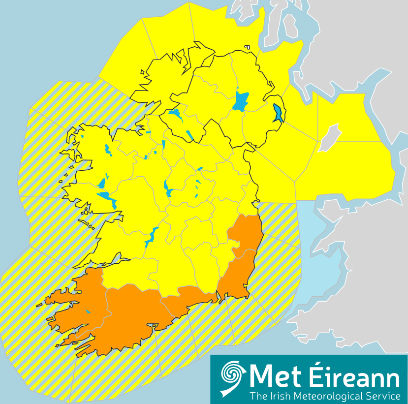
Meanwhile, there are several weather warnings currently in place for the entire country as a result of Storm Babet.
A Status Orange rain warning for Cork and Kerry is to remain in place until 1:00p.m today (Wednesday, October 18).
There is a Status Yellow rain warning for Clare, Limerick, Tipperary and Connacht until 6:00p.m today.
A similar warning for: Carlow; Cavan; Donegal; Dublin; Kildare; Kilkenny; Laois; Longford; Louth; Meath,; Monaghan; Offaly; Waterford; Westmeath; Wexford and Wicklow will be valid until 8:00p.m today.
The UK Met Office has also issued a Status Yellow warning for heavy rain in Northern Ireland from Wednesday afternoon until Thursday morning.
Rainfall
According to figures from Met Éireann, 78.9mm of rain fell at Roches Point in Co. Cork between 6:00a.m yesterday and 11:00a.m today.
In that 29-hour period, 63.5mm of rain was recorded at Sherkin Island and 43.4mm at Moorepark in Co. Cork, while at the Valentia weather station in Co. Kerry, there was 39.8mm of rain.
There has been severe flooding reported in many parts of Co. Cork today.
The Road Safety Authority (RSA) has advised motorists not attempt to drive through flooded roads.
Flooded roads that appear shallow could be deeper than you think. The verge may have subsided and there may also be trees or branches that have fallen that may not be visible, the authority said.
Met Éireann
Mark Bowe, meteorologist with Met Éireann, told Agriland that Storm Babet is more accurately described as a "complex area of low pressure with several embedded weather fronts", the effects of which will be felt in Ireland and the UK over the next few days.
"As we go through the latter parts of today, into the afternoon and evening that heavy band of rain will continue to move north over the country so it will affect more central parts and then more northern parts.
"There will be a bit of a lull in the weather for southern parts of the country between this evening and overnight tonight," he said.
"We are still dominated by a large complex area of low pressure so it's still going to feed in showers in across southern areas.
"You will still be seeing plenty of showers feeding into southern areas pretty much all through tomorrow and that'll continue through tomorrow afternoon and evening, some of those showers may again be heavy," Bowe added.
"As you go into Friday, the showers are going to become more persistent and they will merge into potentially longer spells of rain, particularly along western parts by Friday.
"So the wet weather will really just continue, there won't really seem like there'll be much of a break in it.
"From later on Friday, it pretty much keeps raining across the entire country through the afternoon, with only a bit of a lull coming on Saturday late afternoon," the meteorologist said.