Weather forecast: High pressure to bring largely dry conditions

High pressure will be in control of our weather for the rest of the week, weekend and into the start of next week too, bringing largely dry conditions.
That's according to the latest forecast from Met Éireann.
While there will be a good lot of cloud for much of this week, there will be some bright or sunny spells at times, especially in the east and south and there is likely to be a little bit more in the way of sunshine by the weekend.
Temperatures will come in a little above average and it will remain frost-free.
Looking at the weather forecast for today (Monday, October 6) it will be mostly cloudy across Connacht and Ulster with a little rain or drizzle at times, mainly affecting Atlantic coastal parts.
Across Leinster and Munster, it will be mostly dry with sunny spells, but it will turn a little cloudier during the afternoon with the chance of the odd light shower.
It will be mild for the time of year with highest temperatures of 15°C to 19°, mildest in the east, with south-westerly winds increasing moderate to fresh, strong and gusty in Atlantic coastal parts.

It will become increasingly cloudy tonight, with rain and drizzle moving into parts of the west and north-west and starting to spread south-eastwards.
However, it will stay dry across the east and south with lowest temperatures of 11° to 14° in moderate to fresh south-west winds, stronger in western and north-western parts for a time.
Tomorrow, Tuesday, will see the rain and drizzle continuing to slowly extend south-eastwards across the country, with a few moderate bursts for a time in the west.
A clearance to sunny spells will start to follow from the north-west through the afternoon and evening, though the clearance will not reach parts of the east and south before nightfall.
Highest temperatures tomorrow will range from 12° to 17°, with mostly moderate south-west winds, veering north-west as the rain clears and decreasing light to moderate.
On Tuesday night any remaining rain and drizzle will mostly clear early in the night, just possibly lingering in the far south-east for a while longer.
Otherwise apart from the chance of an isolated light shower, it will be dry, with a mix of cloud and some clear spells.
A few isolated patches of mist and fog may form with lowest temperatures of 6° to 11° with mostly light westerly or variable breezes, moderate westerly in north-western and western coastal parts.
Weather forecast for rest of week
Wednesday will be mostly dry with some bright or sunny spells, the best of these in the east and south.
There will just be a few isolated light showers around. It will become cloudier from the west and north-west through the afternoon and evening with perhaps a few spots of drizzle in the north-west later.
Highest temperatures will range from 12° to 15° in mostly moderate west to north-westerly winds, fresher in the north-west.
While there will be some clear spells in the east and south on Wednesday night, it will be rather cloudy elsewhere.
It will be dry in most areas, though with a little patchy light rain and drizzle likely, mainly in the north-west.
Lowest temperatures of 7° to 12° are expected in light to moderate westerly winds, fresher in the north-west.
Thursday will be a mostly cloudy day, but it will be dry apart from a few spots of light patchy rain and drizzle, mainly in the north-west and west.
Highest temperatures will range from 13° to 16° in light to moderate west to north-westerly winds, fresher for a time in northern coastal parts.
On Thursday night, it will continue mostly cloudy, but mainly dry, with just a little patchy drizzle and mist about. Lowest temperatures of 9° to 13° in light westerly or variable breezes.
Apart from the odd spot of drizzle to begin, Friday will be a dry day. While there will be a good lot of cloud around, some bright or sunny spells will gradually develop.
Highest temperatures will range from 13° to 16° in light westerly or variable breezes.
Outlook for next weekend and next week
Met Éireann has said that high pressure will be centred over or very close to Ireland next weekend.
It's going to be largely dry with variable cloud amounts, and with a better chance of more in the way of bright or sunny spells developing at times.
Highest temperatures by day of 13° to 16° are expected. Lowest night-time temperatures will range from 7° to 12°.
Under any clear spells by night, there is the chance of some mist and fog patches forming in mostly light variable breezes.
There is a strong signal for high pressure to remain the most dominant influence on our weather for the early days of next week, so the largely dry settled conditions will continue.
Farming weather
Drying conditions will be mainly good over the coming days with moderate to fresh winds and generally dry conditions forecast.
Conditions will deteriorate for a time on Tuesday as light rain or drizzle spreads across the country.
There will be limited opportunities for spraying over the next few days due to breezy conditions. There will be better opportunities into next week as winds ease and high-pressure results in mainly dry conditions.
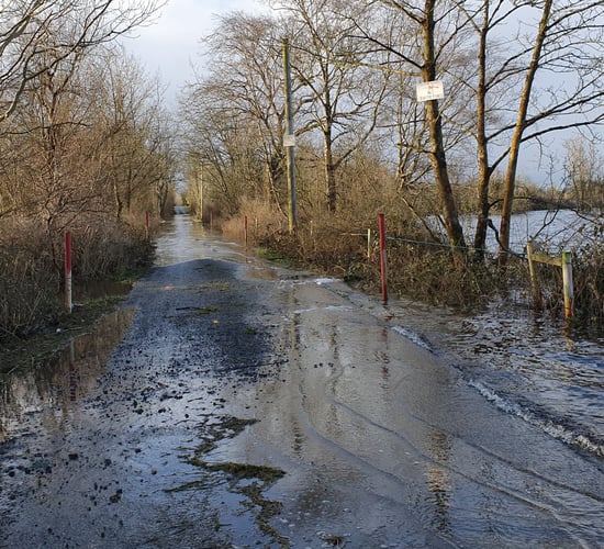
All soils are currently saturated or waterlogged with soil moisture deficits (SMDs) ranging from 1mm in well and moderately drained soils to -10mm in most poorly drained soils, with the exception of some soils in east Leinster which are a little drier.
SMDs will improve a little over the coming week with most well and moderately drained light soils becoming trafficable. Poorly drained soils will continue to be saturated or waterlogged.