Met Éireann: July 2023 set to be the wettest July on record

There was more than four times the amount of rain last month compared to the amount of rainfall in July 2022, according to Met Éireann.
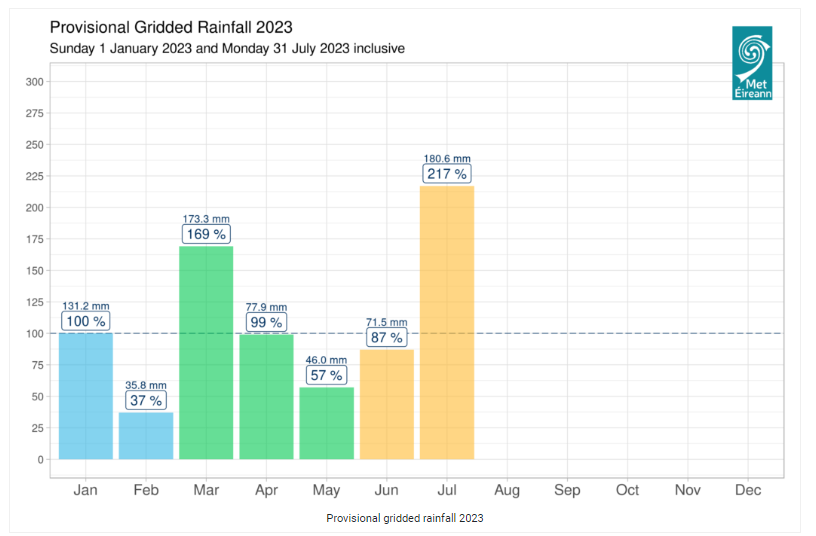
Latest provisional figures, published today (Tuesday, August 1) from the national meteorological service, show that Ireland had 217% of its 1981-2010 Long term Average (LTA) rainfall in July 2023.
According to Met Éireann the figures indicate that the highest daily rainfall total of July 2023, from across its 25 primary weather stations, was 41.6mm at Dunsany, Co. Meath on Saturday, July 22, followed by 41.2mm at Oak Park, Co. Carlow on Monday, July 10.
It also estimated that Raphoe, Co. Donegal had 76.4mm of rainfall on Saturday, July 22, which led to flash flooding in the area.
The latest new rainfall record for the month of July in Ireland continues an unwelcome trend when it comes to local weather patterns.
According to Met Éireann, in the last 12 months Ireland also had its wettest October on record in 2022, its wettest March on record earlier this year and last month its wettest July on record.
The latest provisional figures from the national meteorological service also highlight that some parts of the country endured more non-stop rain that others.
Met Éireann stated that Knock Airport in Co. Mayo "observed 37 consecutive rain days" while there was also up to 15 consecutive wet days at Dunsany in Co. Meath, Malin Head in Co. Donegal and Claremorris in Co. Mayo.
It also explained in its latest monthly weather review why Ireland has had the wettest July on record this year.
"July 2023 saw Atlantic low pressure systems dominating in a mostly westerly or cyclonic airflow.
"Ireland lay on the cooler northern side of the North Atlantic jet stream for most of the month, which was relatively strong for the time of year.
"Numerous active weather fronts crossed the country along with periods of intense, sometimes thundery, convective rainfall," Met Éireann stated.
Meanwhile, according to its latest monthly forecast, the "current meteorological" conditions look set to continue into the early days of August.
"The North Atlantic jet stream is forecast to remain south of the country, meaning it’s likely low pressure systems with associated active weather fronts will continue to dominate our weather," the national meteorological service stated.