Nitrates derogation: Provisional map may reduce impacted area

An as yet unfinalised draft of a map to determine the areas where the nitrates derogation will be reduced may indicate a slight reduction to the area outlined in the Environmental Protection Agency (EPA)'s 'red nitrates map'.
The EPA published a "Water quality monitoring report on nitrogen and phosphorus concentrations in Irish waters 2022" in June containing the 'red' map.
The agency had said that "over 44,000 km2 of land is identified as requiring additional measures to protect water quality".
The map published by the EPA in June is pictured below:
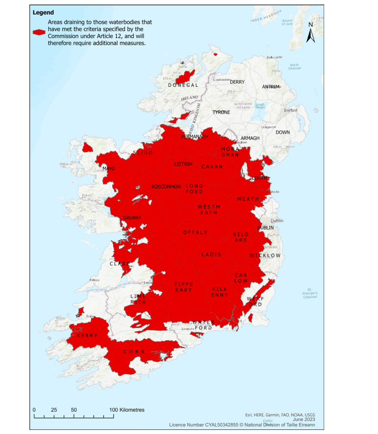
This map identified the areas where farms will likely have to reduce their rate of organic manure nitrogen from 250kg N/ha to 220kg N/ha following a review of water quality required under the Nitrates Directive.
In its June report, the EPA said that, based on the specified water quality criteria set out by the European Commission, when it granted Ireland’s Nitrates Derogation for 2022-2025, “over 44,000 km of land is identified as requiring additional measures to protect water quality”.
The EPA stated in the report: “The commission requires that by January 1 , 2024, derogation farms located within this area reduce their application rate of manure from a maximum of 250kg nitrogen/ha per year to 220kg nitrogen/ha per year.”
As part of that report, the EPA the 'red map' - indicating the large swathes of the country where the derogation would have to be reduced.
The government is required to submit a finalised map to the European Commission, indicating those areas where the derogation will have to be cut to 220kgN/ha.
However, Agriland understands that a provisional version of the map that will be submitted to the commission shows that the land area that will see a derogation cut is 6% lower than the land area shown in the June EPA map.
It is understood that this reduction in impacted land area would mean that 232 farmers who previously would have seen their derogation drop to 220kgN/ha will no longer do so, if this version of the map is signed off on.
However, this map is not finalised, and that further clarification from the EPA on certain aspects of it are required before that can happen, Agriland understands.
Sources have indicated that there is a lack of clarity is over why certain areas were included in the EPA's original map.
It is understood that there also questions of a technical nature, such as what should happen with farmers whose land is located in different parts of the map (i.e. part of the farm is in an area that may remain at 250kgN/ha and part of it is in an area where the derogation must be reduced to 220kgN/ha).
When a final version of this map is confirmed, it will be submitted to the commission, indicating what areas of the country will see a reduction in derogation.