Met Éireann issues rain warning for eastern counties


Met Éireann has issued a Status Yellow weather warning for rain for counties along the east of the country today (Saturday, October 28).
According to the national forecaster, there will be a spell of heavy or thundery rain combined with saturated ground conditions.
The possible impacts of the rainfall are flooding, difficult travel conditions, and disruption to outdoor events, according to Met Éireann.
The warning will come into force from 5:00p.m today (Saturday, October 28) and will remain in place until 4:00a.m on Sunday (October 29).
The Status Yellow rain warning has been issued for the counties of Carlow, Dublin, Kildare, Kilkenny, Laois, Offaly, Wexford, and Wicklow.A Status Yellow rain warning has also been issued to Louth, Meath, Cavan, Monaghan, and Westmeath to apply with the later time of 8:00p.m today until 6:00a.m on Sunday.
Similar to the counties further to the south, a spell of heavy or thundery rain combined with saturated ground conditions will cause the possible impacts in Louth and Meath to be flooding, difficult travel conditions, and disruption to outdoor events.
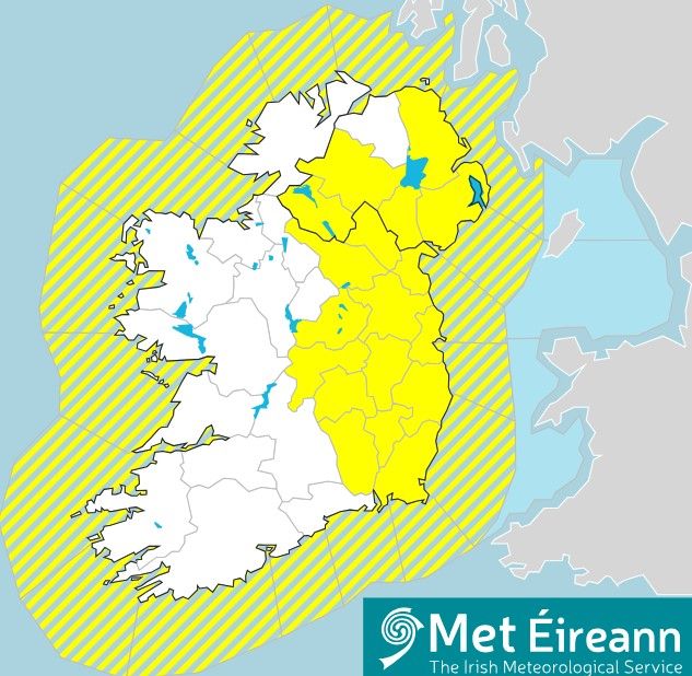
In Northern Ireland, there is a further Yellow rain warning that was issued this morning that is valid from 9:00p.m today until 12:00p.m on Sunday.
This applies to the counties of Antrim, Armagh, Down, Fermangh, and Tyrone.
Across the weekend, Met Éireann determined that the highest temperatures today will be 11° to 14° in moderate to fresh, south to southeast winds, backing easterly later and strengthening on eastern coasts.
Rain will continue to push in from the east leading to a wet Saturday night for most, with fog developing in places. Lowest temperatures should be 4° to 9° with winds strengthening, particularly in parts of the east and north.
It will be cloudy and wet for most on Sunday morning (October 29) with fog lingering in places, especially near southern coasts. The rain will gradually clear westwards with sunny spells and showers following. Highest temperatures will be 9° to 13° in mostly light to moderate variable winds, fresher near coasts.
The weather will be a mix of clear spells and scattered showers overnight on Sunday with fog developing in many areas. Lowest temperatures will be 3° to 7° generally in light to moderate easterly winds.
On Bank Holiday Monday (October 30), fog will clear through the morning to leave another day of sunny spells and showers, some heavy, with thunderstorms and spot flooding possible. Highest temperatures are expected to be 10° to 13° generally in light to moderate east to northeast winds.
There will be further heavy showers expected overnight on Monday, with temperatures falling to between 4° and 8°. Mostly light variable breezes will allow fog to develop once again.
Tuesday (October 31) will see a foggy start to the morning for many with some showers or longer spells of rain, especially in the north. Rain will move into the southwest towards the early afternoon, tracking northeastwards through the rest of the day. Highest temperatures will likely be 10° to 13°.