What do the new soil testing regulations mean for farmers?


From Monday (September 15), there will be new regulations in regards to soil sampling for farmers across the country.
In accordance with SI No. 42 of the 2025 nitrates regulations, soil sample results issued after Sunday (September 14) must state the corresponding Land Parcel Identification System (LPIS) or georeference.
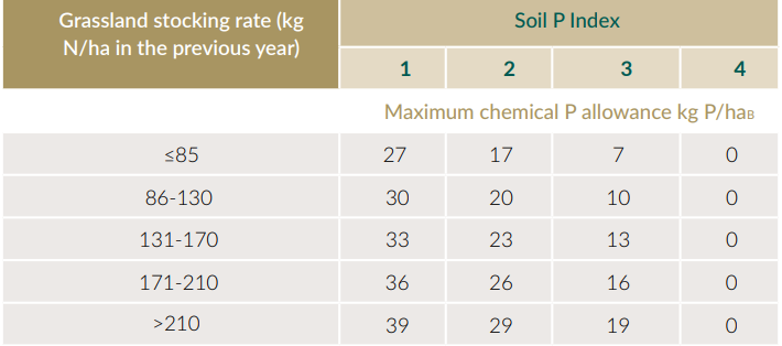
The Department of Agriculture, Food and the Marine (DAFM) have stated that the results of soil tests issued which do not state the corresponding LPIS parcel or georeference will be defaulted to a soil Phosphorus of Index 3 or 4, depending on stocking rates.
An index of 3 or 4 means a meaning a farmer will have no P allowance and will not be allowed to spread any P compound fertilisers.
The change, which comes under the midterm review of Ireland's fifth Nitrates Action Plan (NAP), is linked to direct payments.
Farmers
So what do these new regulations mean to farmers?
Soil samples are valid for four years, meaning farmers will be required to soil test the entirety of their farm at least every four years to ensure they can avail of the higher allowances for soil phosphorus indices 1 and 2.
When doing so, farmers are reminded that a soil sample is required to be taken for a maximum of every 5ha of land.
If up-to-date samples are not taken after that, DAFM will assume your land to be at a index 3 or 4 in terms of phosphorus.
Farms with an organic grassland stocking rate of above 130kg/ha of organic nitrogen will be assumed to be at index 4 if the correct soil sampling is not submitted, while farms below 130kg will be assumed to be at index 3 in the absence of samples.
GPS
A georeference is the precise location a soil sample was taking using Global Positioning System (GPS) co-ordinates.
From Monday (September 15), farmers must have at least one georeference for a single field of less than 4-5ha when sampling, the georeference must be taken from the central point of the sampling path.
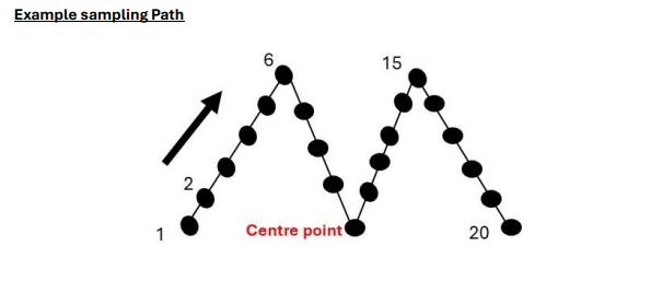
However, DAFM confirmed that a georeferenced point from the sampling path of each field is required if a farmer has a cluster of fields where less than 4-5ha in total are being sampled together.
DAFM stated: "This is due to their similar soil types and the cropping of lands during the previous five years."
These georeferences must be presented as latitude and longitude, using on of the following formats;
- Decimal degrees (DD), e.g. +52.294166 -6.505419.
- Degrees, minutes, seconds (DMS), e.g. 52o 17’ 39.0” N 6o 30’ 19.5” W.
- Degrees and decimal minutes (DMM) e.g. 52° 17.65′ N 6° 30.325′ W.
DAFM confirmed that the georeference or LPIS parcel are not required to be on their farms nutrient management plan (NMP).
However, the department did recommend that farmers align them with their NMPs, to make nutrient recommendations more accurate.
Why the changes?
The department stated that soil sample reports provide valuable information to both DAFM and the farmer in regard to the nutrient status of a soil, helping farmers identify the correct amount of nutrients needed.
DAFM stated that in the past, the location of where the sample was taken was provided by the farmer via field names or map numbers.
Now, the required GPS coordinates and LPIS numbers will confirm accurate testing and assist in compliance checks under the Nitrates Regulations, according to the department.
DAFM stated that the new regulations will help monitor nutrient management on farms across the country.