Sponsored
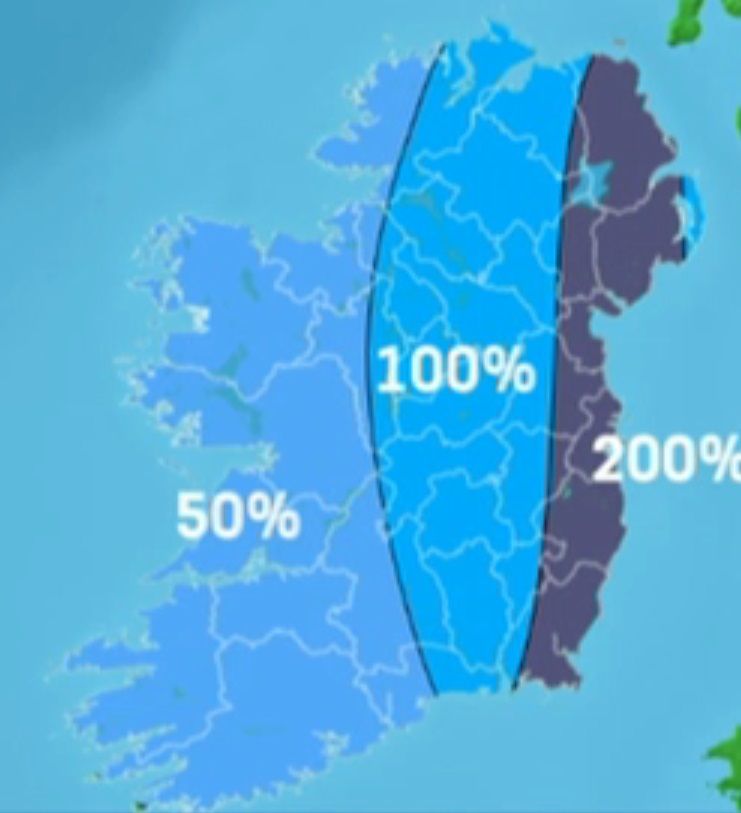
Country of two halves last week when it came to rainfall
Sponsored by
There was contrasting weather across the country this past week.
According to Met Eireann well below usual rainfall totals were recorded across the West and South West of the country with just half of the normal rainfall.
Elsewhere was a different story however, with rainfall amounts 1-2 times the normal, particularly high along the east coast.
According to latest data from Met Eireann, soil temperatures are currently running 1 to 3 degrees above normal. Soil moisture deficits are reasonably low right across the country at present. Ranging from 2mm in the East to 20mm in Connacht.
Looking forward to this week forecasters are saying that the early days of the week will feel quite cool with blustery heavy showers moving west east across the country. The midweek section will be somewhat drier.
According to Met Eireann tomorrow, Tuesday, will be another cool and breezy day, with occasional showers, or longer spells of rain and with risk of thunder. It says there will be some sunny spells also, especially in the east and southeast in the morning and later in the west and northwest.
Showers will become more widespread during Wednesday but all areas will have sunny intervals throughout the day, and the showers will soon become isolated during the evening.
Thursday will be another day of sunny intervals and scattered showers, although only a few showers are likely to be heavy. Friday is likely to be mainly dry across the country with a mixture of cloud and sunny intervals. Moderate, northwesterly breezes will persist but most areas will be mild again.
Latest indications suggest the early part of next weekend may be fairly breezy, with spells of rain or drizzle in many areas but these should clear by Sunday, leaving it mainly dry with sunny spells and near normal temperatures.
Sponsored by