2025 on track to be among 3 warmest years


October 2025 was the third-warmest October globally, with an average surface air temperature of 15.14°C, 0.70°C above the 1991-2020 average for October according to the Copernicus Climate Change Service (C3S).
C3S is implemented by the European Centre for Medium-Range Weather Forecasts on behalf of the European Commission with funding from the EU.
It routinely publishes monthly climate bulletins reporting on the changes observed in global surface air and sea temperatures, sea ice cover and hydrological variables.
Most of the reported findings are based on dataset, using billions of measurements from satellites, ships, aircraft and weather stations around the world.
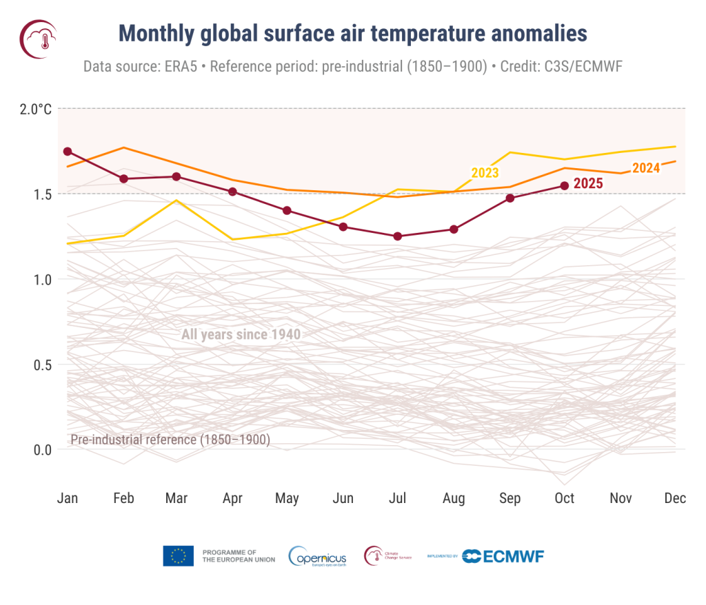
The latest data shows that October 2025 was 0.16°C cooler than the warmest October on record, in 2023, and 0.11°C cooler than October 2024.
October 2025 was 1.55°C above the estimated 1850-1900 average used to define the pre-industrial level, the first month above 1.50°C since April 2025.
The 12-month average temperature from November 2024 to October 2025 was 0.62°C above the 1991-2020 average, and 1.50°C above the pre-industrial level.
Warmest years
2025 is virtually certain to finish as the second- or third-warmest year on record, possibly tied with 2023, the current second-warmest year, and behind 2024, the warmest year on record, according to C3S.
While 2025 may not reach 1.5°C above the pre-industrial level, the average global temperature for 2023–2025 is likely to exceed 1.5°C, which would be the first three-year average to do so in the instrumental period.
Strategic lead for climate, Samantha Burgess commented: “We are now in the decade where the 1.5°C limit is likely to be exceeded, highlighting the accelerating pace of climate change and the urgent need for action.
"October 2025 was the third-warmest October on record globally, and while 2025 may not be the hottest year, it is almost certain to rank in the top three.
"The last three years saw exceptional temperatures, and the average for 2023–2025 is likely to exceed 1.5°C, the first time for a three-year period.”
Europe and other regions
The average temperature over European land for October 2025 was 10.19°C, 0.60°C above the 1991-2020 average for October, ranking outside the 10 warmest on record.
The most pronounced above-average air temperatures for Europe were recorded over Fennoscandia and the southern Iberian Peninsula.
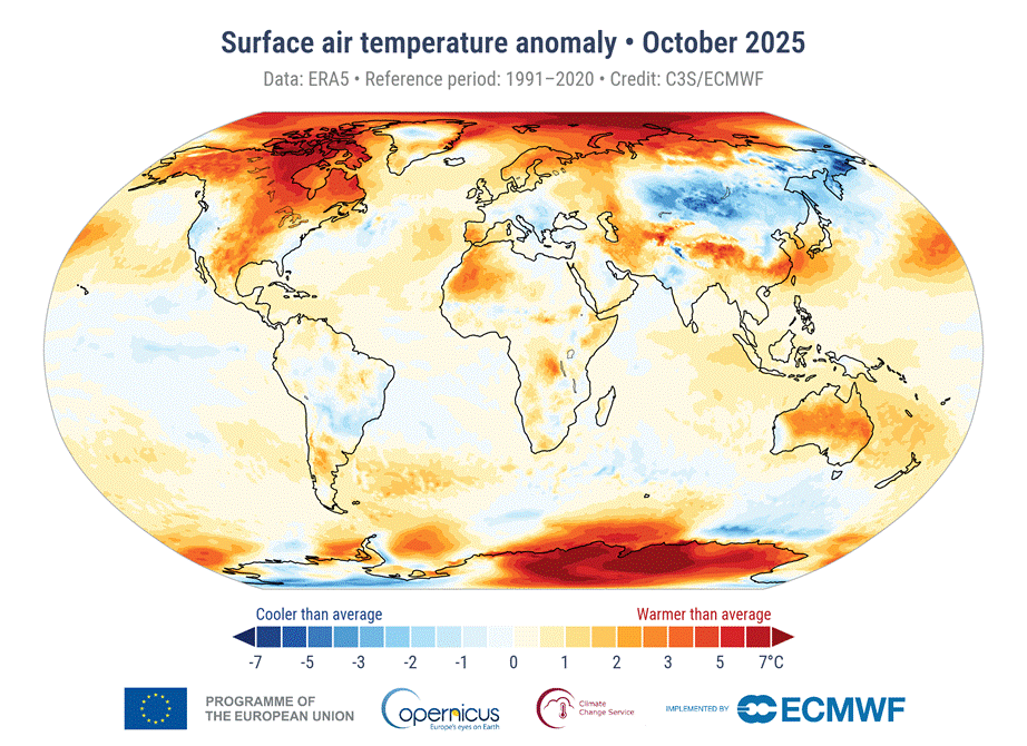
Below-average temperatures were mainly experienced over south-eastern Europe.
Outside Europe, temperatures were most above average over the polar regions, in particular over north-eastern Canada, the central Arctic Ocean and east Antarctica.
A large region with pronounced negative temperature anomalies covered much of southern and eastern Russia and Mongolia, as well as the eastern parts of Kazakhstan and northernmost China.
Hydrological variables
October 2025 was wetter than average in south-eastern Europe, especially across the Balkans, affecting Bulgaria, southern Romania, Serbia, Bosnia and Herzegovina, Greece, and the western coast of Turkiye.
Above-average precipitation also occurred in Norway, Sweden, Denmark, parts of southern France, Ireland, and locally in eastern Spain and the Balearic Islands.
Drier-than-average conditions were seen across most of the Iberian Peninsula, northern Italy, Iceland, and north-eastern Europe.
Beyond Europe, regions with wetter-than-average conditions include the western USA, north-western Mexico, and Alaska, as well as in the Korean Peninsula, eastern China, northern India, Nepal, southern Australia, and southern Chile.
Below-average precipitation was seen in eastern Canada, north-eastern Mexico, northern Africa (including Morocco), the Arabian Peninsula, large parts of Russia, and eastern Australia.