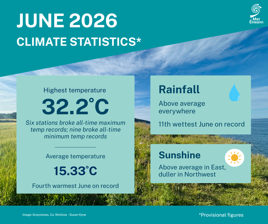
June 2026 was 4th warmest on record - Met Éireann


Provisional figures rank June 2026 as the fourth warmest June in 127 years, according to the latest climate statement issued by Met Éireann.
A heat dome developed over western Europe and resulted in an unusually hot and humid period for Ireland towards the end of last month, and a remarkable number of record-breaking temperatures across the country, Met Éireann said.
In total, nine out of Met Éireann’s 25 principal weather stations witnessed their all-time highest minimum temperature between June 25 and 26 this year, while six stations recorded their all-time highest maximum temperature.
The exceptional conditions also saw only the third and fourth occurrence of a tropical night (overnight minimum temperature higher than 20°) at a principal weather station in Ireland recorded at Oak Park, Co. Carlow and Casement Aerodrome, Co. Dublin on the night of June 25.
Temperature
June had an average temperature of 15.33°, which is 1.65° above the 1991-2020 long term average (LTA) and 2.11° above the 1961-1990 LTA.
Six of the 10 warmest Junes have now occurred since 2001.
The first third of the month was dominated by Atlantic low pressure which brought widespread frontal rain interspersed with showers, sometimes thundery, on most days.
Polar maritime air masses kept it relatively cool during this period, especially in the west.
The second third of the month saw a battleground between high pressure to the south and low pressure to the west while it gradually warmed up.
Initially high pressure built north bringing several dry days before low pressure to the west brought active weather fronts across the country towards the end of the period.
High pressure built over the country again at the beginning of the final third of the month, which led to a drier and sunnier period with temperatures increasing day on day.
A heat dome, that had developed over western Europe, pushed north over the country and culminated in an exceptionally hot and humid period between June 22 and 26.
Thunderstorms
Intense thunderstorms broke out in places on June 25 and 26 before a cooler Atlantic airmass pushed over the country from the west on June 27.
The final few days of the month saw a return to average temperatures and scattered rain or showers interspersed with dry periods.
Rainfall in the month was above average everywhere, driest in the south.
Belmullet, Co. Mayo had its wettest June since 2002 with 127.5mm (174% of its LTA).
Five stations (Phoenix Park, Shannon Airport, Dublin Airport, Markree and Gurteen) had their wettest June since 2012.
Cork Airport had its wettest June since 2013 while Mullingar had its wettest June since 2016.