August 2025 the warmest since 1995 - Met Éireann


August 2025 was the warmest month of 2025 so far and the warmest August since 1995, according to Met Éireann's latest Climate Statement.
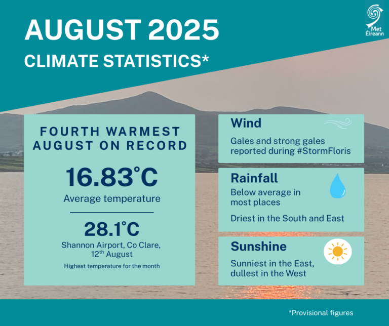
August 2025 was the fourth warmest August and ninth warmest of any month in 126 years of records, with an average temperature of 16.83°C, which is 2.15°C above the 1961-1990 long-term average (LTA) for August and 1.56°C above the more recent 1991-2020 LTA.
Most stations saw rainfall below average (75% of the LTA for Ireland overall), making this August the 22nd driest since 1941.
The highest daily rainfall total was 30.1mm at Athenry, on Thursday 28.
August 2025 was very warm with temperatures well above average at all stations, Met Éireann said.
It was wet in parts of the west but dry elsewhere, especially in the east and south as high pressure dominated through most of the month.
The heat over central and western Europe continued during August, with some of that heat pushing north over Ireland during the second week of the month where several stations saw maximum temperatures up to 28°C on August 12.
During the first week of August 2025, high pressure to the south and low pressure to the north brought a mostly westerly airflow.
This setup allowed several weak weather fronts to cross the country from the west bringing scattered outbreaks of mostly light rain or showers.
Storm
On August 4, Storm Floris, named by the UK Met Office, tracked to the north of Ireland, bringing the strongest winds of the month to the north-west.
The second week saw high pressure building north over Ireland and shifting to the east, drawing a very warm airmass up from the south.
This led to the warmest period of the month with several very warm days.
It stayed mostly dry in the east while the west saw some showers at times.
The third week saw high pressure building to the north keeping it mostly dry nationwide.
However, a north-east airflow brought more cloud and cooler temperatures towards the end of the week.
At the start of the fourth week, a warm front moved in from the south-west, introducing a warmer airmass with a lot of cloud and patchy rain or drizzle at times.
On August 25, the weather pattern shifted dramatically as Ex-Hurricane Erin, named by the National Hurricane Center, moved into the mid-latitudes while transitioning into a mid-latitude storm, and stimulating the North Atlantic jet stream.
Erin’s remnants stalled between Ireland and Iceland, steering several weather fronts, showery troughs and other low pressure systems across the country from the west in a strong westerly airflow, with the heaviest rainfall in the west.